Yellow Aster Butte
Imagine a hike that ticks all the boxes for you - what do you picture? For me, such a hike would need to have some great views of course, but also interesting and varied terrain, lots of places to explore, great fall colors, and enough of a workout to feel like I accomplished something. Lots of hikes tick those boxes though, so to take it to the next level, I also would want to have some lakes that I can use to create reflections in my photos. Finally, to really seal the deal, I’d want to have a buffet of ripe blueberries!
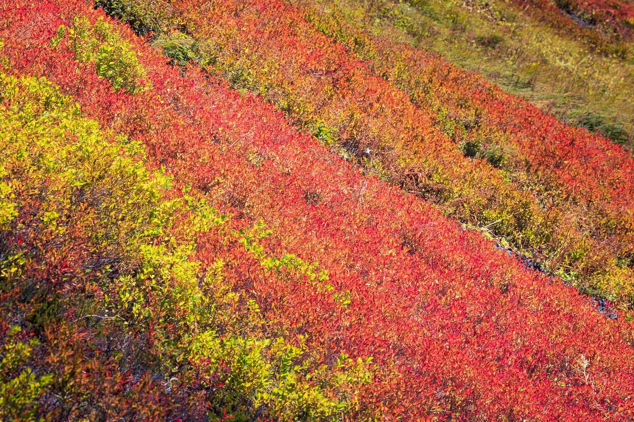
Yellow Aster Butte (or YAB as I like to call it) is a hike that ticks all of these boxes for me, and is perfect in nearly every way. My only complaint is that the masses seem to have discovered it, and trying to visit on a sunny weekend during the fall is asking for a lot of frustration. That being said, with careful timing, a fall visit can be really enjoyable, and YAB really delivers on that front. The colors here are superb, at least as good as anywhere else in the Cascades. Lots of variety in vegetation leads to reds, oranges, and yellows throughout the landscape. Mix that with the evergreen trees in the area, the blue water and sky reflected in the water, and the purple of some distant peaks and the hike is quite literally a rainbow of color!
I’ve been fortunate to visit YAB twice in the last two years during prime fall colors. Not only that, when I visited, the crowds were manageable. An early start or going midweek really helps. The parking situation is a little weird since there are only maybe two parking spaces for the actual trailhead; most people just park on the road. What gets exciting though is that not far past the trailhead, the road turns to a heavily rutted, rocky, high clearance 4x4-only road, so occasionally you have people that go too far and get in over their head. My pro-tip is to drive past the actual trailhead, find a spot to turn around before you go too far, and then park facing downhill. You won’t have to worry about turning around in traffic when you are done!
This trail has a lot of variety. It starts in the forest, and quite steeply. There’s lots of great old growth here to admire. The first mile or so is mostly just up and up in the trees, which makes for a pleasant ascent during hot weather. In the fall, there are also a lot of interesting mushrooms in this section, so keep an eye out for them. The wilderness boundary begins a few hundred yards past the parking lot and you stay in the wilderness the entire time.

Old growth forest not far from the trailhead.

It’s wilderness o’clock!
Soon enough, the trail breaks out of the trees and you reach a junction for Tomyhoi Lake. Staying left here begins the long traverse around the mountainside towards Yellow Aster Butte proper. This section has lots of blueberries to eat when in season! It’s also a nice reprieve from the steep section that begins the trip. After another mile or so, the trail reaches a stream crossing that’s a great spot to refill on water, and offers a peek-a-boo view of Mt. Shuksan too. Another half a mile or so past that, and the views really open up, and Mt. Baker dominates the skyline. It’s here that the first tarn is reached too!

The first trailside tarn and Mt. Baker. Unfortunately the mountain doesn’t really get reflected in the tarn, but it’s pretty anyways.

Mt. Shuksan peeking out from near the creek crossing.

Mt. Baker and colorful hillsides. A trail leads up the tall peak to the right and towards the High Divide.
One thing that’s kind of interesting at this point too is that you will have cell service. Normally, I dislike having cell service on a hike, but this area is in direct view of the Mt. Baker Ski Area and their new cell towers, so you’ll have full reception. That came in handy for me as I was able to make a couple of Facetime calls and show my kids where I was. They really liked that!
Not long after the first tarn, the trail winds up and around a hillside, and a junction is reached. Here, you have a choice. Turn right to head up to the summit of Yellow Aster Butte. Turn left (actually more straight than left) to head down into the lake basin. First-time visitors and peakbaggers should turn right, and here the real ascent begins. It’s only maybe half a mile up to the false summit, but it’s very steep. About halfway up is a really interesting curve in the trail over a very steep drop off, and this feature makes for a really interesting focal point in photos if you turn around and face Mt. Baker.

Looking down on the interesting cliff feature about halfway up to the false summit. Notice the lake basin in the distance as we’ll come back to that!
The ascent may be steep, but the views are stunning, and so the ascent goes by quickly. Eventually, you’ll reach the false summit. This is a fine point to turn around as the views here are as good as any other peak in the region. On a clear day, you’ll have a view of Mt. Baker and Mt. Shuksan of course, as well as all of the tall peaks in North Cascades National Park to the east. From the false summit, you can also look north and see the actual summit of YAB; a faint trail leads that direction if you want to tag the summit proper. Beyond the actual summit are American Border and Canadian Border peaks. As their name implies, they straddle the international border. I think it’s interesting to look at the differences between the US and Canadian side of the border. On the US side, it’s a wilderness area. On the Canadian side, it’s heavily logged.

The true summit of Yellow Aster Butte. American Border Peak is visible in the background.
The summit makes a great destination in its own right, but the real magic of Yellow Aster Butte is the lake basin. Most people skip the lake basin and just go to the peak, but that would be a mistake. The lake basin is accessed from the junction I mentioned earlier. From that junction, it looks like a very steep drop to the lake basin, and it is, but the trail is in great shape and passes through some of the prettiest sections of fall color anywhere in the Cascades. Each step you take into the lake basin reveals more and more, both in the distance with the surrounding peaks, and with the lakes below you.

The trail winds down through colorful brush. Look at all the lakes!
Just awesome colors!

Almost at the bottom.
Once you reach the bottom of the trail, you step into the actual promised land of landscape photography. That’s not really an exaggeration - this place is magical! There are trails leading everywhere, and endless exploration awaits you if you are patient. The first time I visited, I first visited the summit of YAB and then the lake basin, but ran out of time for true exploration of the basin. On my most recent visit, I skipped the summit entirely and just explored and mapped the lake basin. I also named all the lakes, if only for myself so I could keep track of them.
The first lake you come to I decided to call Reflector Lake. This is one of my favorite views in the entire Cascades, and maybe the world. American and Canadian Border Peaks are perfectly framed here. A trail accesses the back side of the lake too, and lots of different vantage points offer lots of different takes on the scene. Beyond Reflector Lake, more tarns offer different views of American Border and Canadian Border Peaks. So many places to explore!

Just going for a casual walk in front of Reflector Lake.

A tiny tarn and creek hidden around Reflector Lake.

I decided to call this tarn Oval Lake. It’s just behind Reflector and offers similar views.

This view greets you when you first arrive in the lake basin.
Beyond Reflector Lake, there are more tarns to explore to the north. The trail eventually leads an overlook of a valley leading down to Tomyhoi Lake, and also connects with the trail the leads up Tomyhoi Peak. Just south of that junction is a large lake I dubbed Y lake, since it is in roughly the shape of a Y. Y Lake is surrounded by lots of largeish boulders, and it reminds me a lot of the Alpine Lakes Wilderness and specifically the Enchantments (no larch trees here though). There are lots of really interesting vantage points around this lake, including some of Yellow Aster Butte itself. Further south from here are even more tarns, some big and some small, but all offering an impressive view in whatever direction you look.

An awesome view from Y Lake. The peaks in the background are (from left to right) Canadian Border, American Border, and YAB’s true summit.

A tiny tarn way off trail above Y Lake.

These boulders reminded me of the Enchantments.
Continuing south from Y Lake, the trail becomes less distinct, and many social trails diverge from the main one. It’s very much a choose your own adventure setup here, and it is well worth your time to explore off trail. Some careful exploration will yield an even more diverse set of lakes. One of my favorites in this area is a lake I call Infinity Tarn, as it looks like an infinity pool with a million dollar view of Mt. Shuksan. Another lake in this area I decided to call Bathtub Lake, as it looked pretty inviting and like a good place to go for a swim (the water was really cold though). Explore and you’ll find your own favorite spots!

Hiking past Infinity Tarn with Mt. Shuksan in the distance.

A tarn I forgot to name, but with a great view nonetheless.
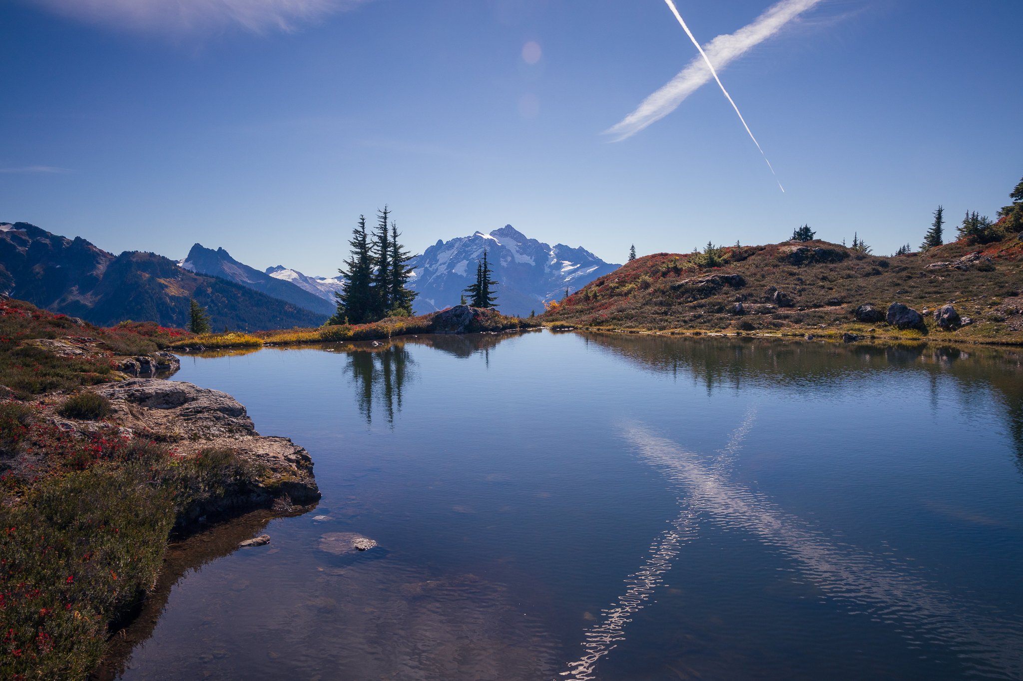
Bathtub Lake reflected a pair of contrails that made an “X” shape!

A different view from Bathtub Lake.
The exploration possibilities in this area are endless. I’ve barely scratched the surface on my visits there. There are still more lakes I need to explore, plus the trail up Tomyhoi Peak to visit, and the trail south towards the High Divide. I intend to make some overnight trips here as soon as I can in order to really fully explore the area and capture the area in different light.
Yellow Aster Butte is one of my top hikes in Washington State. I highly encourage you to check it out, and if you see me out there next fall, say hi!

Unfortunately you do have to return to the trailhead at some point.