Easy Pass
One of my favorite things about the North Cascades is the diversity of the ecosystem. No two places look the same, even though they might be right next door. Easy Pass is an excellent example of this. It’s practically next door to the well-known Maple Pass, yet the scenery is completely different, as is the character of the hike.
Despite the name, Easy Pass isn’t easy. In reading about the history of the name, I found one author suggesting that it was named because it was the easiest way across the Ragged Ridge area. I suppose that might be true, but I also like to think that maybe someone named it just to sandbag everyone who came after! Although the trip is 3.5 miles and around 3,000 feet of gain, most of the gain is earned in the last half of the hike on talus, so it’s much tougher than the raw stats would suggest.
I visited Easy Pass back in July, which was amazingly my first visit in all these years. The trip starts on one of the more interesting footbridges in the area. The big log you walk on is stable, but the handrails most definitely are not. Watch your balance! Once over the bridge, it’s about a mile and a half of pleasant forest walking until you reach a large creek crossing. In early season, this can run really high and fast, but upstream someone laid down a makeshift bridge out of surprisingly thin branches. Crossing was relatively easy though with careful balance.

The footbridge over Granite Creek right by the trailhead.

The makeshift footbridge over high-flowing Easy Pass. In case it isn’t obvious, the bridge is the small group of sticks at center. North Cascades hiking at its finest!
Once over Easy Creek, it’s relatively smooth sailing through open meadows. When I visited, the flowers were still just starting, but the views were great and ever changing as the trail winds up and up. The trail works its way back through a stand of forest before re-emerging into another meadow, just below a talus field.

Trail winding through the meadow on the way to Easy Pass. Easy Pass is the low point on the ridge in the distance.
Once through the last meadow, the real “fun” begins, and by that I mean talus and scree. This is also the steepest section of the trail, and on a hot day it’s quite exposed, so it can be a rough go. I’m not a big fan of talus as I have a bad knee, but taking it slow and pausing to shoot some pictures and enjoy the view made the trek up a lot more enjoyable. One word of caution in this section is that the talus traverses below a larger area of loose rock above, and if you are unlucky it seems plausible that rockfall could occur. Whenever I run into this type of objective hazard in the backcountry, I try to mitigate by moving quickly through the section - something that’s hard to do on a hot day! That said, I didn’t see or hear any rockfall while in the area, but I imagine a hot day might be different.

Entering the talus field. Easy Pass seems close, yet so far!

Looking back down the talus field towards the Highway 20 corridor.
Soon, your efforts are rewarded as you get closer to the pass. Mountains in the basin on the other side start to peek out above the pass, and a stand of alpine larch trees acts as the welcoming committee. In the fall this would be a splendid view!

Almost there! Skirting some cliff bands in the last stretch to the pass. The trees at the pass are starting to become visible.

Peaks on the far side of the pass behind the welcoming committee of alpine larch.

With each step the views just get better!
And then you are there! The view from here is stupendous, maybe the best easily-accessible position in this part of the North Cascades. What makes it so unique is that you have a nearly unspoiled view of a perfect glacially carved U-shaped valley. To the south is the imposing Fisher Peak, and to the west is Mt. Logan. You can see for miles, and it really invites further exploration - although for me that would have to wait for another day. On the day I visited, the light was relatively harsh, but it made for some nice black and whites.

Looking up the valley towards Fisher Peak in the distance. Beautiful alpine scenery!

Mesahchie Peak in the clouds. Mesahchie always seems to be surrounded by clouds whenever I photograph it.
Fisher Peak off in the distance.
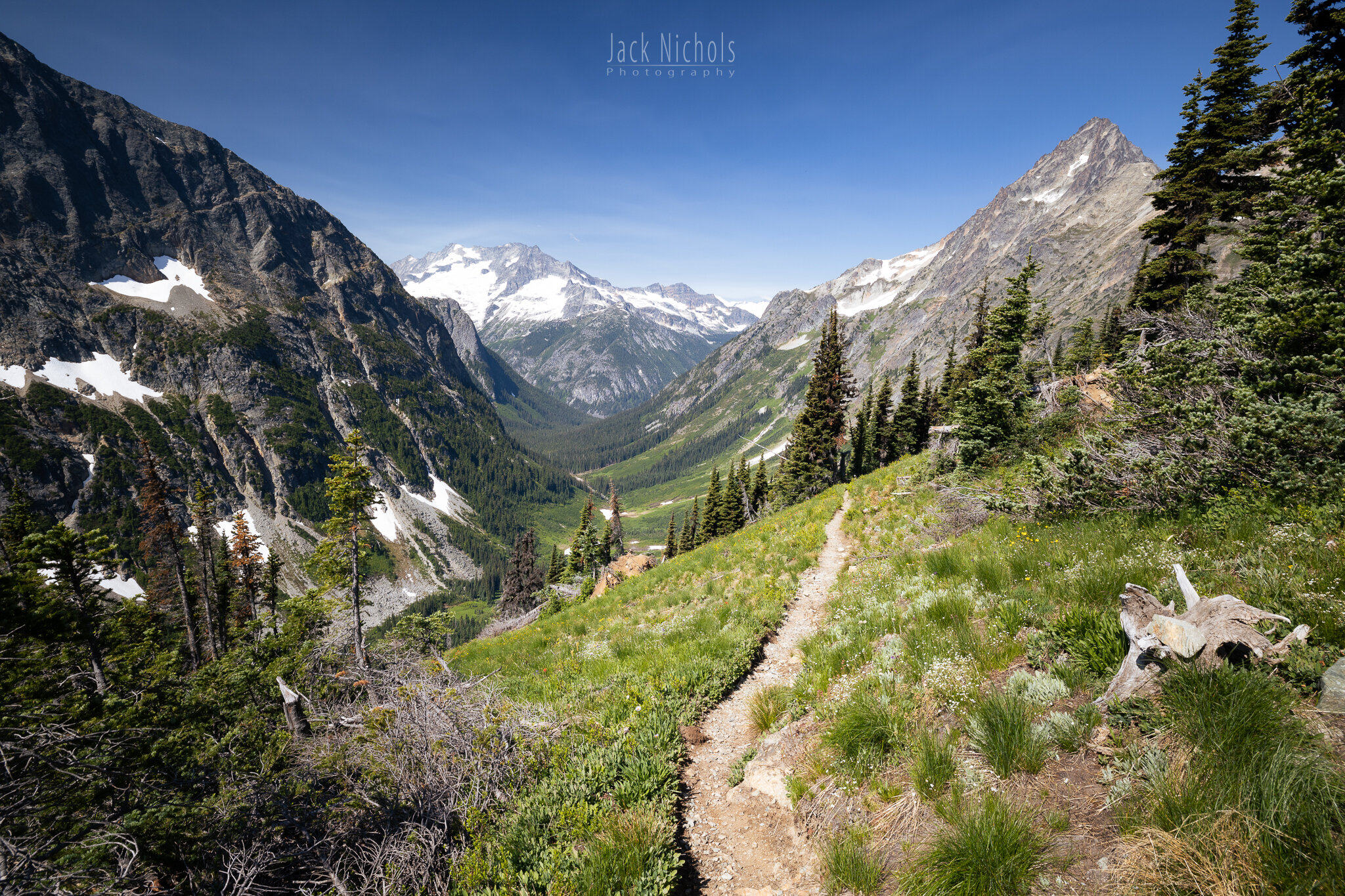
Looking west towards Mt. Logan and the Thunder Creek area. The trail continues until it joins with Thunder Creek, and miles of exploration wait.
The only bad thing about this trip is that you eventually have to head back down! At least the scenery is good in both directions. On my way back out, the sun was at my back so that helped with the lighting. In general, the day didn’t offer the best photo conditions, but that sometimes happens when hiking, and you just have to make the best of it.

Starting down the trail. This little creek was flowing well at the pass, but I can’t say for sure if it will flow in late summer.

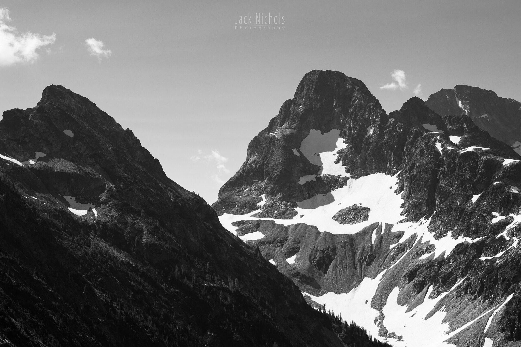
A pair of ridges above the trail looked pretty ominous in black and white.
In all, Easy Pass was a great trip. Much less crowded than the hikes down the street, and I think the views are better too. It’s not for everyone though - on my way out, I ran into quite a few people that looked and acted quite unprepared. One such couple I ran into on the way out I saw again in the parking lot about 10 minutes after I got there; I suppose they turned around after realizing they were in over their head. The steepness, the terrain, and the heat can sneak up on you, and there is no shame in turning around if you are struggling.
If you go, the key to success is an early start to avoid the heat (and the people too), and to plan for water. The creek is flowing well enough that it should provide year-round water, but after the final creek crossing that’s the last water. A filter will be necessary given the position and foot traffic. If you have more time, longer trips can be made over the pass into Fisher basin, but you’ll need an overnight permit from the park office in Marblemount first.